**** MOVE MOUSE IN BOX OR CLICK IN BOX TO PAUSE - CLICK ON ANY UNDERLINED ITEM FOR A LINK TO THAT ISSUE **** ** Unseasonably warm mid-week ** Late-week cold front with not much impact ** No significant rain in the forecast for the Corpus Christi Water Shed. ** Combined water levels 9.0% ** More details in our 'Latest Weather Brief' box below. ** Strong El Nino setting up in Eastern Pacific ** Pre-season tropics forecast: Near-normal 2026 season, with 14 named storms, 7 hurricanes, 3 major hurricanes. ** If you would like to be added to our Weather Notification List or have something that you would like to see added to our website, or find any 'non working links' Cick HERE and let us know. ** Please share our website with your friends and family. ** Thanks for viewing our website.

Tampa Bay Fl Radar:

Live Weather Radio - Click On Link Below

DISCLAIMER: This website, http://www.coastalbendweather.com, is for general information only and not to be used for any official forecast. This site is made to provide as many useful links and information possible for hurricane tracking and knowledge. Please first consult  your official sources, the NWS and NHC before making decisions on any kind of weather event. We are also not responsible for the correctness of maps or data on this page.


Other Radars:

LATEST SATELITE VIEWS (Use Scroll Bar On Right)

Visible (red) Imagery for S. Texas/Southwest Gulf

Use Your Mouse To Move/Zoom, etc

Local TV Stations - Click On Link Below

Use Your Mouse To Move/Zoom, etc

Latest Storm 2024-14 Discussion -- Automatically Updates

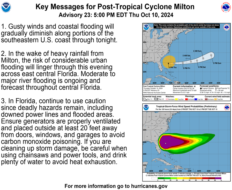
LOCAL WEATHER SERVICE HURRICANE STATEMENTS - *When Posted*

 For 'Official Information' ALWAYS rely on the official information sources from your immediate area officials for information and instructions.

CORPUS RADAR:

Satelitte Floater Views (Courtesy of cyclonicwx.com)

Water Vapor

EMERGENCY INFORMATION

Latest Storm 2024-14 Advisory -- Automatically Updates

Local Weather Service Info - Click On Link Below

JACKSONVILLE FL RADAR:

Latest Satellite View

Click On Any Box For Larger View


      To Pause, Place Mouse In Box

Activity: Storm MILTON 2024-14

MILTON IS FORECAST TO QUICKLY INTENSIFY WHILE IT MOVES EASTWARD TO NORTHEASTWARD ACROSS THE GULF OF MEXICO AND BE AT OR NEAR MAJOR HURRICANE STRENGTH WHEN IT REACHES THE WEST COAST OF THE FLORIDA PENINSULA MID WEEK.

AREAS OF HEAVY RAINFALL WILL ALSO IMPACT PORTIONS OF FLORIDA SUNDAY AND MONDAY WELL AHEAD OF THE TROPICAL SYSTEM, WITH HEAVY RAINFALL MORE DIRECTLY RELATED TO THE SYSTEM EXPECTED BY LATER TUESDAY THROUGH WEDNESDAY.

...Storm MILTON Formed in the South Gulf of Mexico will cross the Gulf towards the western Florida coastline.......MAJOR FLOOD THREAT FOR THE SOUTHWESTER FLORIDA, POSSIBLY TAMPA REGION

****************

Remember,it never hurts to check your tropical activity plans, check your go kits, and be sure to check that your insurance coverage is up to date as we head into what is predicted to be a very active hurricane season.
******************

We hope you will pass our website on to your friends and family
All information on this page for this event is self refreshing to provide you the latest data.
******************

For 'Official Information' ALWAYS rely on the official information sources from your immediate area officials for information and instructions.

Latest Wind Map View - With Your Mouse Left Button You Can Drag This View