DISCLAIMER STATEMENT
THIS WEBSITE IN NO MANNER WHATSOEVER ENDORSES ANY WEBSITES LINKED TO, PRODUCTS, SOFTWARE, OR ANY OTHER CONTENT ON THIS ENTIRE WEBSITE. ALL WEATHER INFORMATION IS FOR INFORMATION ONLY AND AS SUCH SHOULD NOT BE USED AS AN OFFICIAL SOURCE. ALWAYS REFER TO YOUR LOCAL AUTHORITIES FOR OFFICIAL INFORMATION.
All links, images, etc., are automatically from outstanding originating websites. As such, this site is not responsible for the accuracy of links or image content.
For use and/or rebroadcasting guidelines, please visit the the linked site originators. This website is independently maintained as a service only with no commercial content or intent.
DO NOT RELY ON THIS WEBSITE OR ANY OTHER WEBSITE THAT IS NOT AN 'OFFICIAL' WEBSITE FOR YOUR PERSONAL PLANNING.
LIKE ALL OTHER WEBSITES, WE GET OUR INFORMATION FROM MANY DIFFERENT SOURCES IN ORDER TO PROVIDE YOU WITH A ONE-STOP WAY OF GETTING GENERAL INFORMATION AND SHOULD BE TAKEN AS SUCH.
For any information on this website, contact us via the above CONTACT button.
Live Weather Radio - Click Below (Any of these stations May Be Temp Offline)
Click picture for larger version
Latest Tropical Discussion From The Hurricane Center
Latest Wind Map View - With Your Mouse Left Button You Can Drag This View
Click picture for larger version
(Clickable Links In Red)
Coastal Waters Forecast Active Watches and Warnings
Next 1-5 Day Rain Totals Next 7-Day Rain Totals
Regional Radar (Real Time) Corpus Radar (Real Time)
All is quiet again in the tropics. Looking at both the American and the European models, no indication of major activity thru the 17th.
With this in mind, there are some strong tropical waves coming off of Africa way out in the Eastern Atlantic that models are 'hinting' at some possible development. Of course, this is WAY out in the future, so just mentioning this.
Our website is constantly monitoring each model update and will keep the website up to date.
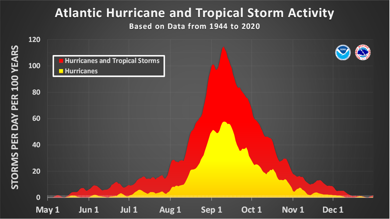
Keep in mind that we are heading to the peak time frame for the 2026 hurricane season, the 2nd week of September.
Always, monitor your local 'Official' weather information outlets for the latest weather and warning activity.
Links to all of the models are on our website and set to update automatically. (Both our home page and our Tropical pages)
We will send out updates to those on our 'Notification List' as warranted.
Here is the latest run of the American Model.
We hope you will forward our website info to your friends, neighbors, and family. It is always good to get the word out.
Thanks for viewing our website.
Latest Tropical Outlook From The Hurricane Center
Gulf Of America Tropics: For The Latest on Edouard Go To Edouard Page
Click On Any Box For Larger View - Give Images Time To Load



Latest Satellite 'Visable' Image
